Maps have historically been used as powerful tools of colonization, often reinforcing Eurocentric worldviews, territorial claims, and narratives that marginalize Indigenous cultures and perspectives. Eurocentric maps often omit or misrepresent Indigenous territories, place names, and cultural landmarks. Decolonizing maps refers to a process that challenges and revises traditional maps to address the biases, inaccuracies, and colonial perspectives inherent in many cartographic representations. This week in the mentoring circle, we look at several digital resources that support our endeavor to undo map distortions and create more inclusive, accurate, and culturally sensitive representations of geographic spaces.
Creating accurate world maps is a mathematically challenging task, as maps are flat representations of our spherical planet. The Earth, being a sphere, cannot be portrayed on a flat surface without some degree of distortion. In the accompanying video, Johnny Harris demonstrates this by cutting open a plastic globe, providing a visual explanation of the complexities involved in transforming a spherical object into a flat map. This demonstration is an excellent educational tool, helping students understand the challenges of mapmaking. It also highlights the trade-offs made when choosing one map projection over another, as each projection distorts certain features while preserving others.
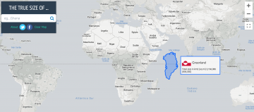
The Mercator projection, widely used in services like Google Maps, maintains the shape of countries but significantly distorts their size, particularly near the poles. In common educational maps, for instance, Alaska appears larger than Mexico, and Greenland seems roughly the same size as Africa. However, in reality, Mexico is actually larger than Alaska, and Africa is about 14 times the size of Greenland. To explore this further, visit ‘The True Size Of‘ website, which allows for a direct comparison of country sizes as depicted in the Mercator projection, revealing the true scale of geographical areas. The controversy surrounding the Mercator projection stems from its tendency to exaggerate the size of northern countries, thereby giving them undue prominence, while diminishing the apparent size of countries in the southern hemisphere.
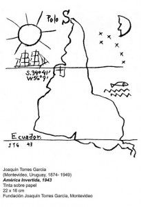 What if we flipped the map, placing the south at the top and the north at the bottom? How might our historical perspective shift if this were the norm? The striking artwork by Uruguayan constructivist artist Joaquin Torres-Garcia illustrates this exact reversal. This leads to another thought-provoking question: Why is Great Britain often at the center of world maps? The brief answer is colonialism. In an accompanying video, Johnny Harris delves into how traders capitalized on England’s colonial holdings, such as India, Canada, Australia, and South Africa. For these traders, centring maps around London facilitated easier collaboration within the empire. However, this approach led to a significant challenge: the complexity of managing multiple time zones. As a result, the standardization of time zones became a necessity, fundamentally altering our perception of the world.
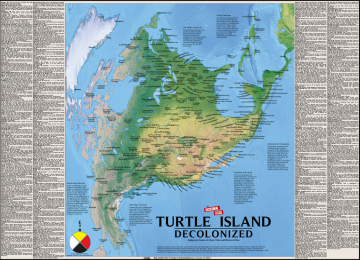
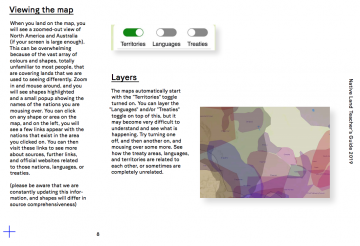
The colonial legacy is also evident in the creation of numerous invisible borders: imaginary lines that have fragmented land, communities, and homes. For many Indigenous peoples, territories are defined not by these arbitrary borders, but through deep connections with family, community, and the land, nurtured and stewarded across generations. Native-Land.ca is a website dedicated to mapping Indigenous lands in a manner that respects and honours these relationships. It aims to transform, challenge, and enrich our understanding of national histories and the stories of different peoples. By mapping Indigenous territories, treaties, and languages worldwide, Native-Land endeavours to transcend colonial perspectives, offering a representation that aligns more closely with how Indigenous peoples envision their own identity and heritage.
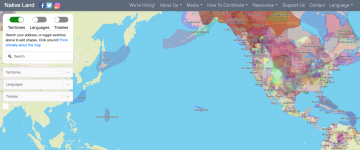
Native-Land is a Canadian registered not-for-profit organization with a predominantly Indigenous Board of Directors. These board members bring intimate connections to their land bases, communities, and a profound understanding of Indigenous ways of being and knowing. The organization also offers educational resources aimed at reshaping discussions about colonialism and Indigeneity, promoting awareness of territorial rights in daily conversations and actions. Their Teacher’s Guide is particularly resourceful, providing comprehensive instructions for utilizing the Native-Land platform. It includes various exercises tailored for educators teaching diverse age groups, from children to adults. The guide not only addresses the strengths and limitations of the map but also underscores the importance of understanding colonialism. Furthermore, it equips teachers with additional resources for deepening their knowledge in these areas.
Native-Land facilitates important conversations about colonization, land rights, language, and the intertwining of Indigenous history with our personal narratives. Last year, the CTLT Indigenous Initiatives welcomed Christine McRae, Executive Director of Native-Land, to speak on these topics. The accompanying video offers insights into how Native Land Digital promotes education and engagement regarding Indigenous lands, particularly in relation to your own location. It is an invitation to learn about and acknowledge the rich cultures that have developed from the lands where we teach, live, work, learn, and play. Such recognition reminds us, whether we are settlers, uninvited visitors, or welcomed guests, of our collective duty to honour and establish reciprocal relationships with the land’s original caretakers.
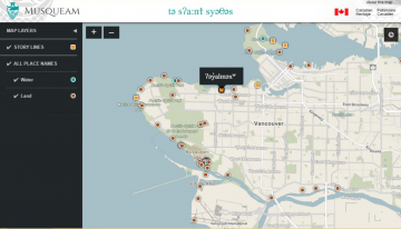
Maps have historically been used to assert colonial power and territorial dominance. Decolonizing maps involves recognizing and respecting the sovereignty of Indigenous nations, challenging colonial borders, and acknowledging the true complexity of historical and contemporary land relationships. This process involves a profound understanding of how borders have impacted Indigenous communities. Around the world, many places have been renamed by colonizers, often leading to the erasure or overshadowing of their original Indigenous names. Decolonizing maps involves restoring and prioritizing Indigenous place names, respecting the linguistic and cultural diversity inherent in these names. To begin our journey into decolonizing maps, let’s use the Musqueam Place Names Map to hear audio of place names in hən̓q̓əmin̓əm̓ language from Musqueam Elders.