Making accurate world maps is mathematically impossible. Maps are flat representations of our spherical planet. The world is a sphere which makes it impossible to draw it on a flat surface without distorting it in some way. In the video below, watch Johnny Harris cut open a plastic globe to understand just what it takes to turn a sphere into something flat. This activity is great for students to understand the struggle to make a flat map out of a globe and the trade-offs that occur when a projection that distorts certain attributes while preserving others, is chosen over another.
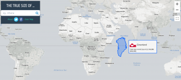
The Mercator projection (most-used map) preserves the shape of countries while distorting the size, especially near the north and south pole. In maps that we teach we see that Alaska appears larger than Mexico and that Greenland looks about the same size as Africa. In reality, Mexico is larger than Alaska and Africa is about 14x the size of Greenland. Go to the website: The True Size Of to compare the sizes of countries in the Mercator projection and learn the truth about maps. What makes the Mercator projection particularly controversial is that it makes northern countries look much larger than they really are, giving them more prominence while taking it away from southern countries.
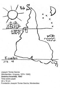 What would happen in we flipped the map. Would our history be different if the south were the top and the north the bottom? The beautiful artwork on the side by Uruguayan constructivist artist Joaquin Torres-Garcia represents this exact turnaround. A related question comes to mind, have you ever wondered why Great Britain is always at the centre of the world maps? The short answer: colonialism. In the following video, Johnny Harris explains how traders took advantage of England’s colonial holdings such as India, Canada, Australia and South Africa. For traders, most maps were centred around London to make collaboration with the empire easier to achieve. The only problem was time. As tens of timezones existed, timekeeping became more important than ever. Standardising time would change the way we look at the world forever, literally.
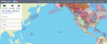
The same colonial impact could be seen in the invention of many invisible borders. Imaginary lines that have divided the land, communities and homes. Territories are created through relations with family, community and land. Lands traditionally steward by Indigenous people from generation to generation. Native-Land.ca is a website who strives to map Indigenous lands in a way that honours these relations to change, challenge, and improve the way we see the history of our countries and peoples. Native-Land strives to map Indigenous territories, treaties, and languages across the world in a way that goes beyond colonial ways of thinking in order to better represent how Indigenous people want to see themselves.
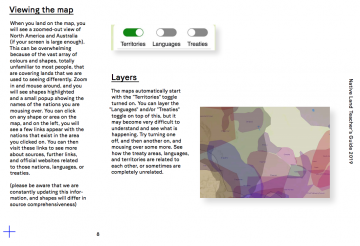
Native-Land is a registered Canadian not-for-profit organization who has a majority-Indigenous Board of Directors, representing people who have close ties to land bases, communities, and deep knowledge about Indigenous ways of being and knowing. They also provide educational resources to correct the way that people speak about colonialism and Indigeneity, and to encourage territory awareness in everyday speech and action. In their Teacher’s Guide, they include detailed instructions on how to use Native-Land, as well as exercises for use by teachers of different levels, from kids to adults. The Teacher’s Guide discusses the pros and cons of the map itself, the importance of learning more about colonialism, and provides resources for teachers to learn more.
Native-Land brings about discussions of colonization, land rights, language, and Indigenous history tied to our personal histories. Last year, the CTLT Indigenous Initiatives hosted Christine McRae, Executive Director of Native-Land. In the following video, you will learn about ways that Native Land Digital encourages education and engagement on topics of Indigenous land—particularly, where you are located. Watch to learn more about ways that you can acknowledge and discuss the rich cultures that have evolved from the land where you teach, live, work, learn and play. Through this acknowledgement we are reminded as settlers, uninvited visitors or welcomed guests of our shared responsibility to give reverence and build reciprocal relationships with the original stewards of the land.